Introduction
On June 8, 2026, at approximately 0:37 local time, a magnitude 7.8 earthquake, with a depth of 55 km, struck 26 km Southwest of Kablalan, Philippines. The coordinate of epicenter of the earthquake was 5.59N, 125.05E.
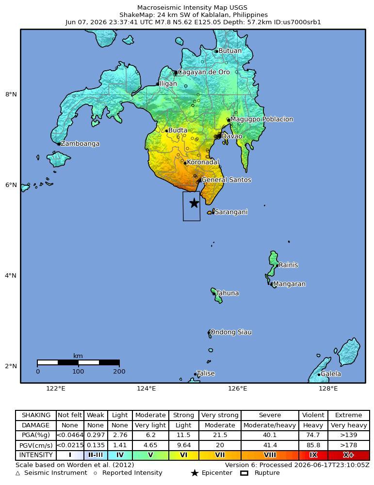
Tectonic Summary
The Philippine Sea plate is bordered by the larger Pacific and Eurasia plates and the smaller Sunda plate. The Philippine Sea plate is unusual in that its borders are nearly all zones of plate convergence. The Pacific plate is subducted into the mantle, south of Japan, beneath the Izu-Bonin and Mariana island arcs, which extend more than 3,000 km along the eastern margin of the Philippine Sea plate. This subduction zone is characterized by rapid plate convergence and high-level seismicity extending to depths of over 600 km. In spite of this extensive zone of plate convergence, the plate interface has been associated with few great (M>8.0) ‘megathrust’ earthquakes. This low seismic energy release is thought to result from weak coupling along the plate interface (Scholz and Campos, 1995). These convergent plate margins are also associated with unusual zones of back-arc extension (along with resulting seismic activity) that decouple the volcanic island arcs from the remainder of the Philippine Sea Plate (Karig et al., 1978; Klaus et al., 1992).
South of the Mariana arc, the Pacific plate is subducted beneath the Yap Islands along the Yap trench. The long zone of Pacific plate subduction at the eastern margin of the Philippine Sea Plate is responsible for the generation of the deep Izu-Bonin, Mariana, and Yap trenches as well as parallel chains of islands and volcanoes, typical of circum-pacific island arcs. Similarly, the northwestern margin of the Philippine Sea plate is subducting beneath the Eurasia plate along a convergent zone, extending from southern Honshu to the northeastern coast of Taiwan, manifested by the Ryukyu Islands and the Nansei-Shoto (Ryukyu) trench. The Ryukyu Subduction Zone is associated with a similar zone of back-arc extension, the Okinawa Trough. At Taiwan, the plate boundary is characterized by a zone of arc-continent collision, whereby the northern end of the Luzon island arc is colliding with the buoyant crust of the Eurasia continental margin offshore China.
Along its western margin, the Philippine Sea plate is associated with a zone of oblique convergence with the Sunda Plate. This highly active convergent plate boundary extends along both sides the Philippine Islands, from Luzon in the north to the Celebes Islands in the south. The tectonic setting of the Philippines is unusual in several respects: it is characterized by opposite-facing subduction systems on its east and west sides; the archipelago is cut by a major transform fault, the Philippine Fault; and the arc complex itself is marked by active volcanism, faulting, and high seismic activity. Subduction of the Philippine Sea Plate occurs at the eastern margin of the archipelago along the Philippine Trench and its northern extension, the East Luzon Trough. The East Luzon Trough is thought to be an unusual example of a subduction zone in the process of formation, as the Philippine Trench system gradually extends northward (Hamburger et al., 1983). On the west side of Luzon, the Sunda Plate subducts eastward along a series of trenches, including the Manila Trench in the north, the smaller less well-developed Negros Trench in the central Philippines, and the Sulu and Cotabato trenches in the south (Cardwell et al., 1980). At its northern and southern terminations, subduction at the Manila Trench is interrupted by arc-continent collision, between the northern Philippine arc and the Eurasian continental margin at Taiwan and between the Sulu-Borneo Block and Luzon at the island of Mindoro. The Philippine fault, which extends over 1,200 km within the Philippine arc, is seismically active. The fault has been associated with major historical earthquakes, including the destructive M7.6 Luzon earthquake of 1990 (Yoshida and Abe, 1992). A number of other active intra-arc fault systems are associated with high seismic activity, including the Cotabato Fault and the Verde Passage-Sibuyan Sea Fault (Galgana et al., 2007).
Relative plate motion vectors near the Philippines (about 80 mm/yr) is oblique to the plate boundary along the two plate margins of central Luzon, where it is partitioned into orthogonal plate convergence along the trenches and nearly pure translational motion along the Philippine Fault (Barrier et al., 1991). Profiles B and C reveal evidence of opposing inclined seismic zones at intermediate depths (roughly 70-300 km) and complex tectonics at the surface along the Philippine Fault.
Several relevant tectonic elements, plate boundaries and active volcanoes, provide a context for the seismicity presented on the main map. The plate boundaries are most accurate along the axis of the trenches and more diffuse or speculative in the South China Sea and Lesser Sunda Islands. The active volcanic arcs (Siebert and Simkin, 2002) follow the Izu, Volcano, Mariana, and Ryukyu island chains and the main Philippine islands parallel to the Manila, Negros, Cotabato, and Philippine trenches.
Seismic activity along the boundaries of the Philippine Sea Plate (Allen et al., 2009) has produced 7 great (M>8.0) earthquakes and 250 large (M>7) events. Among the most destructive events were the 1923 Kanto, the 1948 Fukui and the 1995 Kobe (Japan) earthquakes (99,000, 5,100, and 6,400 casualties, respectively), the 1935 and the 1999 Chi-Chi (Taiwan) earthquakes (3,300 and 2,500 casualties, respectively), and the 1976 M7.6 Moro Gulf and 1990 M7.6 Luzon (Philippines) earthquakes (7,100 and 2,400 casualties, respectively). There have also been a number of tsunami-generating events in the region, including the Moro Gulf earthquake, whose tsunami resulted in more than 5000 deaths.
More official event information is available from USGS Event Page.
Building Damage
Current Situation
The June 8, 2026 magnitude 7.8 earthquake in the southern Philippines caused widespread building damage, including collapsed and damaged buildings across Mindanao and especially in General Santos City [1][2][55]. In General Santos City, reports documented a collapsed Jollibee fast food restaurant, multiple collapsed buildings, damaged buildings, and rescue or assessment operations at collapsed structures [3][5][9][15][17][19][21][30][35][38][41][42][49][53]. Damage in the city included shops and buildings with broken signs and glass, some reduced to piles of concrete and rubble, as well as damaged convenience stores and cracked building walls [32][60]. Several multi-story buildings reportedly collapsed in General Santos, while numerous smaller structures across the region collapsed or sustained severe damage; several low-rise buildings also collapsed or sustained heavy damage [36][59]. A later damage account reported more than 3,100 homes damaged, along with government buildings, roads, and bridges [27]. Residential-area damage was also reported at Peta Timur village in Sangihe Islands Regency, Indonesia's North Sulawesi province [7]. Authorities advised people to check homes and other structures before entering because aftershocks could cause damaged buildings to collapse [37].
Temporal Evolution
Building damage reporting centers on persistent, repeatedly recirculated reports of concentrated structural damage in General Santos, including collapses, heavy damage, and visible facade/wall damage. Over time, coverage becomes more specific through recurring named-facility cases, quantified damaged homes, and repeated building-focused rescue/assessment and reentry-safety reporting, while Sarangani damage reporting preserves an early no-collapse assessment alongside later localized building damage evidence.
Temporal Tracks
General Santos / locality-level building damage severity and collapse pattern
General Santos is persistently tracked as the main building-damage concentration, with recurring reports of partial collapses, complete collapses, extensive damage, rubble, and visible facade/wall damage.
Jollibee-linked building in General Santos / collapse status
A Jollibee-linked structure is repeatedly reported as collapsed, evolving from broader shopping-centre wording to direct building/restaurant identification.
Collapsed or damaged buildings in General Santos City and Mindanao / search, rescue, and assessment process
Reporting intermittently tracks building-focused rescue and assessment, from initial searches for trapped people to repeated collapsed-building operations in General Santos and broader Mindanao search/assessment activity.
Damaged buildings and houses in the Philippines / reentry safety guidance
Authorities consistently warned against immediate reentry into damaged buildings and advised pre-entry checks because aftershocks could trigger collapse.
Mindanao and southern Philippines housing stock / damaged homes count
A quantified metric of over 3,100 damaged homes appears mid-sequence, disappears from some analyzed reporting intervals, then reappears unchanged.
Sarangani province / building damage and collapse-assessment picture
Sarangani reporting combines early numerous-damage reporting and an assessment with no collapsed buildings yet reported, followed later by localized residential building damage evidence.
Metric Series
Mindanao and southern Philippines housing stock / damaged homes count was reported as over 3,100 homes damaged.
Mindanao and southern Philippines housing stock / damaged homes count
Reference List
Current Situation Sources
Infrastructure Impact
Current Situation
Bridge infrastructure damage was reported in General Santos, where a bridge cracked and small buildings partially collapsed, according to the regional director of the Office of Civil Defense [1]. A separate report stated that the earthquake damaged buildings and cracked a key access bridge in the southern Philippines [23]. Airport operations were disrupted in General Santos: the earthquake forced the closure of General Santos International Airport, and the Civil Aviation Authority of the Philippines reported that the airport was temporarily shut with 17 domestic flights canceled or cancelled [2][3][4][6]. Another report stated that the Civil Aviation Authority of the Philippines suspended all operations at General Santos City Airport after the earthquake [21]. General Santos International Airport was later reopened on Monday after a six-day closure due to the 7.8 magnitude earthquake that hit Mindanao [22]. Overall infrastructure damage was also reported, with statistics indicating landslides and damaged infrastructure estimated at 15 million Philippine pesos, equivalent to US$243,897 [5].
Temporal Evolution
Infrastructure reporting is dominated by repeated accounts of disruption at General Santos International Airport, including closure/suspension, 17 canceled domestic flights, reported structural damage, and later reopening after a six-day closure. Secondary recurring infrastructure impacts include cracked or damaged bridges in General Santos, cracked roads in South Cotabato, later Sarangani road disruption, and a quantified PHP 15 million infrastructure damage estimate.
Temporal Tracks
General Santos International Airport / operational status
Airport operational reporting began with shutdown and suspension claims, remained persistent for many reporting intervals, and later incorporated reopening after a six-day closure while closure claims still continued to circulate.
General Santos International Airport / physical damage condition
Airport damage reporting persisted from broad severe-damage claims to later component-specific damage, and eventually coexisted with a statement that the facility was structurally sound after safety assessment.
General Santos International Airport / flight cancellations
The count of canceled domestic flights remained fixed at 17 across nearly the entire sequence.
General Santos bridge / key access bridge / damage condition
Bridge reporting moved from generic damage and cracks to dangerous cracks on a key access bridge, then disappeared from several reporting intervals before reappearing repeatedly.
Philippines local infrastructure / damage estimate
A later-introduced infrastructure damage estimate stayed fixed at PHP 15 million when reported.
South Cotabato road / damage condition
A South Cotabato road-cracking report appeared early, disappeared for many reporting intervals, then reappeared later with similar wording.
Metric Series
General Santos International Airport / flight cancellations was reported as 17 domestic flights canceled. Philippines local infrastructure / damage estimate was reported as 15 million Philippine pesos (US$243,897) PHP.
General Santos International Airport / flight cancellations
Philippines local infrastructure / damage estimate
Reference List
Current Situation Sources
Resilience and Recovery
Current Situation
The most recent reported casualty figure from the National Disaster Risk Reduction and Management Council (NDRRMC), dated June 18, states that at least 78 people were killed and 30 remained missing after the June 8 magnitude 7.8 earthquake off Sarangani province in the southern Philippines [9]. Earlier NDRRMC and Office of Civil Defense updates show the toll increasing from 37 deaths on June 9 to 45 on June 10, 55 on June 12, 61–65 on June 13–15, and 78 by June 18 [58]. As of June 14, NDRRMC reported 61 deaths, 1,403 injured individuals, and 40 missing persons, providing the highest cited injury count in the available facts [10]. Community disruption was substantial, with NDRRMC reporting as of June 14 that more than 173,000 households, equivalent to about 724,000 people, had been affected by the earthquake [18]. Another NDRRMC-cited report stated that about 1.5 million people were affected and that 22,000 people were still residing in temporary shelters, indicating continued displacement beyond the immediate impact period [23]. The earthquake also displaced thousands, according to a later report that cited at least 65 fatalities and at least 36 missing persons after the June 8 event [5]. Immediate response actions included the mobilization of Philippine military and disaster response teams while authorities verified preliminary reports of deaths and injuries across Mindanao, with many casualties attributed to falling debris and landslides [1]. Manila also stepped up search and rescue operations after disaster officials reported at least 32 deaths and dozens of injuries from the magnitude 7.8 earthquake off Mindanao [6]. President Ferdinand Marcos Jr. suspended school classes in affected areas of Mindanao and called on coastal residents to evacuate immediately [4]. Philippine authorities and Indonesia urged residents to move to higher ground after a tsunami of up to three feet struck parts of the Philippine coastline [45]. Tsunami-related evacuation measures extended beyond the Philippines, with warnings issued for the Philippines, Japan, and Indonesia and coastal residents evacuated [78]. Warnings were cancelled after more than six hours in the southern Philippines, northern Indonesia, and Malaysia’s Sabah state, where coastal residents had earlier been instructed to evacuate immediately to higher ground [90]. Teresito Bacolcol, head of the Philippine institute, specifically advised people in coastal areas to evacuate to higher ground or move farther inland [7]. Following the earthquake, NDRRMC urged the public to participate actively in emergency drills to strengthen disaster preparedness, response capability, and public safety [2]. Singapore also offered assistance and stated that it stood ready to assist the Philippines after the Mindanao earthquake [61][62].
Temporal Evolution
Resilience reporting evolved from highly conflicting early casualty and missing-person figures plus immediate tsunami-evacuation actions, toward larger NDRRMC casualty totals, broader affected-population reporting, shelter/relief details, and recurring preparedness messaging. The reporting also repeatedly recirculated earlier lower counts and warning-era actions alongside later higher official totals, so competing observations remain temporally important rather than fully resolved here.
PAGER Estimates
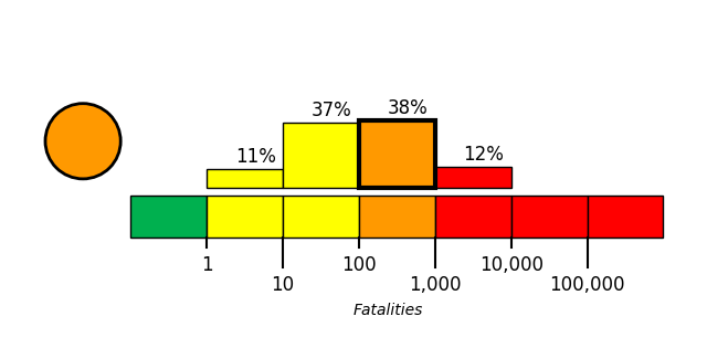
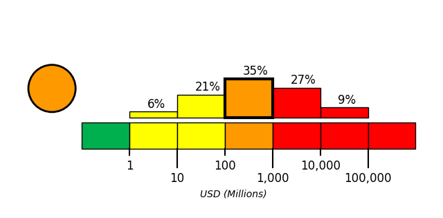
USGS PAGER tool estimated the fatalities to be in the orange alert level, which is most likely between 100 and 1,000 with a probability of 38%. USGS PAGER tool estimated the economic loss to be in the orange alert level, which is most likely between 100 and 1,000 million dollars with a probability of 35%.
Temporal Tracks
Mindanao earthquake / reported death toll
Death reporting moved upward overall but repeatedly mixed newer official totals with older preliminary or lower counts.
Mindanao earthquake / reported injury toll
Injury estimates rose from low hundreds to over 1,400, but older counts and under-verification figures kept resurfacing.
Mindanao earthquake / reported missing-person count
Missing-person reporting moved from conflicting local General Santos counts to higher Mindanao-wide totals, then later decreased.
Philippines coastal warning response / tsunami warning and evacuation-action cycle
The core warning process repeatedly appears as issuance/evacuation guidance followed by cancellation or lifting, often retold in later coverage.
Philippine government and responders / response mobilization and search-and-rescue posture
Mobilization, standby, and stepped-up search-and-rescue remained a stable response narrative across the reporting window.
Affected Mindanao schools / class suspension status
School classes remained suspended throughout the analyzed reporting reporting intervals with no observed reopening signal.
Metric Series
Mindanao earthquake / reported death toll remained variable across reports; latest observations included at least 78; 61; 35 preliminary; at least 32 people. Mindanao earthquake / reported injury toll remained variable across reports; latest observations included 1403; 134 preliminary; dozens people. Mindanao earthquake / reported missing-person count remained variable across reports; latest observations included 30; 40 people.
Mindanao earthquake / reported death toll
Mindanao earthquake / reported injury toll
Mindanao earthquake / reported missing-person count
Philippines affected population / affected households and people
Reference List
Current Situation Sources
Sources and Evidence Notes
Temporal Evidence Source Domains
Product Scope and Use Notes
- This product summarizes reported information available in the selected reporting snapshots; it is not an official damage assessment.
- A missing or dropped observation means it was not observed in the analyzed evidence for that interval, not that the real-world condition ended; readers should interpret these gaps as limits of the available reporting record.
- When reports contain conflicting accounts or continue to repeat older values and statuses, this briefing preserves that uncertainty rather than forcing the evidence into a single resolved conclusion.
- For more detailed article-level context, consult the cited news and source links included with the current-situation citations and temporal evidence source domains.
General Santos is persistently tracked as the main building-damage concentration, with recurring reports of partial collapses, complete collapses, extensive damage, rubble, and visible facade/wall damage.
- newly reportedsevere localized building damage
Initial reporting showed several partial collapses, heavy damage, cracked walls, broken signs/glass, and some buildings reduced to rubble in General Santos.
- persistedsevere localized building damage
General Santos damage reporting persisted with several buildings damaged or completely collapsed and visible wall/store damage.
- escalatedmultiple collapses extensive damage
Coverage escalated in specificity to multiple building collapses, extensive damage, rubble, and reported multi-story collapses in General Santos.
- persistedmultiple collapses extensive damage
The same severe General Santos collapse-and-damage pattern remained in circulation.
- updatedmultiple collapses extensive damage
Reporting continued to combine multiple collapses, extensive damage, visible facade damage, and at least one small-building collapse in General Santos.
- broadened in scopeworst affected damage concentration
General Santos was explicitly described as the worst affected area for building damage.
- persistedworst affected damage concentration
The worst-affected framing and severe collapse/damage pattern persisted.
- persistedmultiple collapses extensive damage
General Santos damage remained characterized by partial collapses, collapsed buildings, extensive damage, and rubble.
- persistedworst affected damage concentration
Worst-affected framing reappeared alongside several buildings damaged or completely collapsed and small buildings severely damaged.
- persistedmultiple collapses extensive damage
General Santos coverage remained dense, spanning a few to several collapsed buildings, low-rise and multi-story collapses, and extensive damage.
- persistedmultiple collapses extensive damage
The same severe General Santos building-damage concentration continued, including multiple collapsed buildings and partial collapses.
- recirculated older reportingmultiple collapses extensive damage
Late reporting still recirculated the concentrated General Santos collapse-and-extensive-damage narrative.
A Jollibee-linked structure is repeatedly reported as collapsed, evolving from broader shopping-centre wording to direct building/restaurant identification.
- newly reportedcollapsed
A shopping centre with a Jollibee fast-food restaurant was reported collapsed into rubble in General Santos City.
- persistedcollapsed
The shopping-centre-with-Jollibee collapse remained in reporting.
- updatedcollapsed
Reporting became more direct, identifying a collapsed Jollibee fast food restaurant in General Santos City.
- persistedcollapsed
The collapsed Jollibee fast food restaurant continued to be cited.
- persistedcollapsed
The Jollibee collapse remained unchanged in reporting.
- updatedcollapsed
Video evidence and police-at-scene references made the Jollibee collapse more specific and visually anchored.
- persistedcollapsed
The collapsed Jollibee restaurant remained in reporting.
- persistedcollapsed
No substantive change; the Jollibee collapse persisted.
- persistedcollapsed
AFP-verified and local-government video again tied the collapse to the Jollibee-linked fast-food building.
- updatedcollapsed
Both shopping-centre-with-Jollibee and Jollibee-building formulations circulated together.
- persistedcollapsed
The fast-food building collapse and explicit Jollibee building collapse remained in evidence.
- recirculated older reportingcollapsed
Late reporting reporting intervals still referenced the same collapsed Jollibee facility.
Reporting intermittently tracks building-focused rescue and assessment, from initial searches for trapped people to repeated collapsed-building operations in General Santos and broader Mindanao search/assessment activity.
- newly reportedactive search and rescue
Search and rescue teams were working to find possibly trapped people in collapsed or severely damaged facilities.
- reappeared in reportingrescue and assessment at collapsed building
Collapsed-building rescue and assessment in General Santos City reappeared in reporting.
- persistedrescue and assessment at collapsed building
The same collapsed-building rescue and assessment activity persisted.
- persistedrescue and assessment at collapsed building
No substantive process change; rescue and assessment reporting continued.
- updatedrescue and assessment at collapsed building
Rescue operations outside the collapsed building added more scene-specific detail to the same response process.
- persistedrescue and assessment at collapsed building
The collapsed-building rescue and assessment process persisted in General Santos City.
- persistedrescue and assessment at collapsed building
Assessment and rescue operations at the collapsed building continued to be cited.
- reappeared in reportingongoing search rescue and assessment
Building-focused response reappeared and broadened to include ongoing Mindanao searches, Red Cross assessment, and the familiar General Santos collapsed-building operations.
- persistedongoing search rescue and assessment
Late reporting retained ongoing search for trapped people in collapsed or severely damaged buildings and damage assessment activity.
- updatedrescue and assessment at collapsed building
The General Santos collapsed-building rescue/assessment package reappeared again in late coverage.
Authorities consistently warned against immediate reentry into damaged buildings and advised pre-entry checks because aftershocks could trigger collapse.
- newly reportedreentry cautioned
People were told to seek advice before returning to damaged buildings and houses because of collapse risk from aftershocks.
- persistedreentry cautioned
The same reentry caution persisted.
- updatedreentry cautioned with preentry inspection
Guidance expanded to include checking homes and structures for damage before entering them.
- persistedreentry cautioned with preentry inspection
Both warning forms remained active: avoid return and inspect before entry.
- persistedreentry cautioned
The seek-advice-before-returning message persisted.
- updatedreentry cautioned with preentry inspection
Reporting again combined preentry inspection with advice before returning.
- persistedreentry cautioned with preentry inspection
The same combined reentry-safety guidance persisted.
- persistedreentry cautioned
Warnings continued to discourage return to damaged buildings because aftershocks could cause collapse.
- persistedreentry cautioned
The seek-advice warning remained in circulation.
- updatedreentry cautioned with preentry inspection
Late reporting coverage again combined avoid-return and inspect-before-entry messages.
- persistedreentry cautioned
The seek-advice-before-returning warning persisted.
- updatedpreentry inspection advised
Late reporting still emphasized checking homes and structures before entering them.
A quantified metric of over 3,100 damaged homes appears mid-sequence, disappears from some analyzed reporting intervals, then reappears unchanged.
- newly reportedreported
The earthquake was reported to have damaged over 3,100 homes.
- persistedreported
The same damaged-homes figure was repeated.
- reappeared in reportingreported
The over-3,100 damaged homes figure reappeared unchanged in late reporting coverage.
Sarangani reporting combines early numerous-damage reporting and an assessment with no collapsed buildings yet reported, followed later by localized residential building damage evidence.
- newly reporteddamage reported no collapse confirmed yet
Sarangani was reported to have numerous damaged buildings while assessment was underway and no collapsed buildings had yet been reported.
- reappeared in reportinglocalized damage with early no collapse note
Sarangani evidence reappeared with a damaged residential building in Glan while also repeating the early no-collapsed-buildings assessment note.
- narrowed in scopelocalized damage reported
Localized residential building damage in Glan persisted in reporting.
| Snapshot Time | Reported Value | Change |
|---|---|---|
| 2026-06-15T13:00:00Z | over 3,100 homes | newly observed |
| 2026-06-16T13:00:00Z | over 3,100 homes | persisted |
| 2026-06-19T13:00:00Z | over 3,100 homes damaged | reappeared |
- [1] straitstimes.com
MANILA – A 7.8-magnitude earthquake struck southern Philippines on June 8, killing at least 35 peopl... - [2] stripes.com
Tsunami warnings rippled across the Pacific on Monday after a magnitude 7.8 earthquake struck the so... - [3] eu.jacksonville.com
WORLDCollapsed buildings and chaos after deadly Philippines earthquakeJune 8, 2026, 10:46 a.m. ETPol... - [5] eu.jacksonville.com
A 7.8-magnitude earthquake that struck the southern Philippines on June 8 killed at least one person... - [7] eu.jacksonville.com
A 7.8-magnitude earthquake that struck the southern Philippines on June 8 killed at least one person... - [9] eu.jacksonville.com
A 7.8-magnitude earthquake struck the southern Philippines on June 8, killing at least 15 people, co... - [15] eu.jacksonville.com
A 7.8-magnitude earthquake struck the southern Philippines on June 8, killing at least 15 people, co... - [17] eu.jacksonville.com
The earthquake in the southern Philippines killed at least 31 people, according to provincial author... - [19] eu.jacksonville.com
The earthquake in the southern Philippines killed at least 31 people, according to provincial author... - [21] eu.jacksonville.com
The earthquake in the southern Philippines killed at least 31 people, according to provincial author... - [27] timesofindia.indiatimes.com
"Our priority now is to monitor the coast to determine if there are indications the water had recede... - [30] prokerala.com
This photo taken on June 8, 2026 shows a damaged building after a 7.8 magnitude earthquake in Genera... - [32] oneindia.com
Images from the local information office in General Santos City showed visible destruction after the... - [35] tribuneindia.com
NEW VIDEO: Building collapses in General Santos, Philippines following powerful earthquake. - [36] newsbreak.com
The earthquake started off the shore of the southern Philippines, where it caused several low-rise b... - [37] newsbreak.com
The director of the Philippine Institute of Volcanology and Seismology reportedly told people in the... - [38] m.dailyadvent.com
A collapsed building is seen after an 7.8 magnitude earthquake in General Santos City on June 8, 202... - [41] m.dailyadvent.com
This photo shows a damaged building after an 7.8 magnitude earthquake in General Santos City on June... - [42] m.dailyadvent.com
Responders conduct a rescue operation at a collapsed building after a 7.8 magnitude earthquake in Ge... - [49] m.dailyadvent.com
A responder gestures while assessing a collapsed building after a 7.8 magnitude earthquake in Genera... - [53] m.dailyadvent.com
People observe the rescue operations outside a collapsed building after a 7.8 magnitude earthquake i... - [55] indianexpress.com
A 7.8-magnitude earthquake today, June 8, 2026, caused multiple building collapses and extensive dam... - [59] aol.com
Several multi-story buildings were reported to have collapsed in General Santos, while officials sai... - [60] businesstimes.com.sg
Damage to buildings, utilities and infrastructure was still being assessed, but the worst affected a...
Airport operational reporting began with shutdown and suspension claims, remained persistent for many reporting intervals, and later incorporated reopening after a six-day closure while closure claims still continued to circulate.
- newly reportedtemporarily shut
Airport was temporarily shut.
- updatedoperations suspended for safety assessment
Shutdown reporting persisted and became more specific with all operations suspended and safety assessments cited.
- persistedall operations suspended
Airport closure and suspension reporting persisted.
- persistedsuspended
Operational disruption remained active with suspension and safety-assessment language.
- persistedoperations suspended for safety assessment
Airport closure/suspension reporting continued with multiple equivalent formulations.
- persistedall operations suspended
Airport disruption reporting remained in circulation.
- persistedtemporarily shut
Airport closure reporting persisted.
- reported reopenedmixed closed and reopened reporting
Reporting carried both closure/suspension claims and a reopening after a six-day closure.
older status language recirculated - reported reopenedmixed closed and reopened reporting
Reopening remained in evidence, but temporary shutdown language also persisted.
older status language recirculated - reported reopenedmixed closed and reopened reporting
Airport reporting again mixed shutdown, suspension due to structural damage, and reopening.
older status language recirculated - recirculated older reportingtemporarily closed
Only closure/suspension wording was observed in this reporting interval.
- reported reopenedmixed closed and reopened reporting
Closure wording, reopening after six days, and a completed safety assessment before reopening all coexisted in reporting.
older status language recirculated
Airport damage reporting persisted from broad severe-damage claims to later component-specific damage, and eventually coexisted with a statement that the facility was structurally sound after safety assessment.
- newly reportedmassive damage reported
Airport reportedly sustained massive damage.
- persistedmassive damage reported
Massive damage reporting persisted.
- persistedmassive damage reported
Massive damage reporting persisted again.
- persistedmassive damage reported
Massive damage reporting continued.
- persistedmassive damage reported
Massive damage reporting remained active.
- reappeared in reportingmassive damage reported
Massive damage reporting reappeared.
- reappeared in reportingdamaged
Damage reporting returned as multiple damages.
- reported with conflicting accountscomponent damage and structural sound assessment
Damage reporting became more specific with control tower and passenger terminal damage, while also introducing a structurally sound assessment before reopening.
The count of canceled domestic flights remained fixed at 17 across nearly the entire sequence.
- newly reportedcancellations reported
17 domestic flights were canceled.
- persistedcancellations reported
The same 17-flight cancellation count persisted.
- persistedcancellations reported
The same 17-flight cancellation count persisted.
- persistedcancellations reported
The same 17-flight cancellation count persisted.
- persistedcancellations reported
The same 17-flight cancellation count persisted.
- persistedcancellations reported
The same 17-flight cancellation count persisted.
- persistedcancellations reported
The same 17-flight cancellation count persisted.
- persistedcancellations reported
The same 17-flight cancellation count persisted.
- persistedcancellations reported
The same 17-flight cancellation count persisted.
- persistedcancellations reported
The same 17-flight cancellation count persisted.
- persistedcancellations reported
The same 17-flight cancellation count persisted.
- persistedcancellations reported
The same 17-flight cancellation count persisted.
Bridge reporting moved from generic damage and cracks to dangerous cracks on a key access bridge, then disappeared from several reporting intervals before reappearing repeatedly.
- newly reporteddamaged or cracked
A key bridge was reported damaged and a bridge was reported to have cracks.
- updateddangerous cracks
Reporting became more specific as dangerous cracks on a key access bridge.
- reappeared in reportingcracked
Bridge cracking reappeared.
- persistedcracked
Bridge cracking persisted.
- broadened in scopedamaged or cracked
Bridge reporting broadened to multiple cracked and damaged formulations, including dangerous cracks on a key access bridge.
- persisteddamaged cracked
General Santos bridge cracking persisted with dangerous cracks and cracked bridge language.
- persistedcracked
Bridge cracking continued in General Santos and southern Philippines reporting.
A later-introduced infrastructure damage estimate stayed fixed at PHP 15 million when reported.
- newly reporteddamage estimate reported
Infrastructure damage was estimated at 15 million Philippine pesos.
- reappeared in reportingdamage estimate reported
The PHP 15 million infrastructure damage estimate reappeared unchanged.
- persisteddamage estimate reported
The PHP 15 million infrastructure damage estimate persisted unchanged.
A South Cotabato road-cracking report appeared early, disappeared for many reporting intervals, then reappeared later with similar wording.
- newly reportedroad cracked
Large cracks were reported on a road in South Cotabato Province.
- reappeared in reportingroad section cracked
A road section in South Cotabato was reported cracked.
- reappeared in reportingroad cracked
Large cracks on a South Cotabato road were again reported.
| Snapshot Time | Reported Value | Change |
|---|---|---|
| 2026-06-08T13:00:00Z | 17 domestic flights canceled | newly observed |
| 2026-06-09T13:00:00Z | 17 domestic flights canceled | persisted |
| 2026-06-10T13:00:00Z | 17 domestic flights canceled | persisted |
| 2026-06-11T13:00:00Z | 17 domestic flights canceled | persisted |
| 2026-06-12T13:00:00Z | 17 domestic flights canceled | persisted |
| 2026-06-13T13:00:00Z | 17 domestic flights canceled | persisted |
| 2026-06-14T13:00:00Z | 17 domestic flights canceled | persisted |
| 2026-06-15T13:00:00Z | 17 domestic flights canceled | persisted |
| 2026-06-16T13:00:00Z | 17 domestic flights canceled | persisted |
| 2026-06-17T13:00:00Z | 17 domestic flights canceled | persisted |
| 2026-06-18T13:00:00Z | 17 domestic flights canceled | persisted |
| 2026-06-19T13:00:00Z | 17 domestic flights canceled | persisted |
| Snapshot Time | Reported Value | Change |
|---|---|---|
| 2026-06-16T13:00:00Z | 15 million Philippine pesos (US$243,897) | newly observed |
| 2026-06-18T13:00:00Z | 15 million Philippine pesos (US$243,897) | reappeared |
| 2026-06-19T13:00:00Z | 15 million Philippine pesos (US$243,897) | persisted |
- [1] stripes.com
At least seven people were killed and 12 more were missing in General Santos, a coastal city of more... - [2] timesofindia.indiatimes.com
It also forced the closure of General Santos International Airport and disrupted classes in several ... - [3] houstonpublicmedia.org
The international airport in General Santos was temporarily shut, and 17 domestic flights were cance... - [4] local.newsbreak.com
The international airport in General Santos was temporarily shut due to the earthquake, and 17 domes... - [5] taipeitimes.com
The earthquake caused landslides and damaged infrastructure with damage estimated at 15 million Phil... - [6] thehindu.com
The international airport in General Santos was temporarily shut due to the earthquake and 17 domest... - [21] aol.com
After the earthquake rattled the country, the Civil Aviation Authority of the Philippines suspended ... - [22] ph.headtopics.com
The Civil Aviation Authority of the Philippines reopened General Santos International Airport on Mon... - [23] m.rediff.com
At least four people were killed and more than 200 injured after a powerful 7.8-magnitude offshore e...
Death reporting moved upward overall but repeatedly mixed newer official totals with older preliminary or lower counts.
- newly reportedconflicting counts
Conflicting early fatality figures appeared across local, regional, and nationwide scopes.
- updatedstill conflicting
At least 37 deaths became the lead figure, but 32 preliminary deaths remained in circulation.
- reported with conflicting accountshighly conflicting
The reporting widened into sharply divergent counts from 1 up to at least 41 deaths.
- escalatedupward but conflicting
A higher 53-death report appeared alongside older 37-, 35-, and 32-death references.
- escalatedofficial totals rising
NDRRMC introduced higher official totals including at least 47 and at least 55 deaths while lower local figures persisted.
- persistedmixed old and new
Coverage persisted with both 55/47-death official figures and older lower counts.
- persistedmixed old and new
At least 55 deaths remained in use, with 32 under verification still present.
- escalatedhigher official total with recirculation
Reporting climbed to at least 61 deaths while older values remained visible.
- escalatedhigher official total with recirculation
NDRRMC advanced the death toll further to at least 68, but a 35-death preliminary figure still appeared.
- updatedstale and current mixed
Reporting returned to at least 61 deaths while 32 preliminary deaths were still mentioned.
- escalatedhighest reported total
NDRRMC raised the toll to at least 78 deaths and explicitly summarized the upward revision path.
- persistedhighest total with stale recirculation
At least 78 deaths persisted as the highest cited total, but 61, 35 preliminary, and 32 reappeared in the same reporting interval.
Injury estimates rose from low hundreds to over 1,400, but older counts and under-verification figures kept resurfacing.
- newly reportedconflicting counts
Early injury reporting was fragmented across several low-hundreds figures.
- escalatedhigher but mixed
Around 500 injuries emerged as the main count, while 134 injuries stayed under verification.
- reported with conflicting accountshighly conflicting
The injury stream became highly divergent, ranging from single digits to nearly 500.
- persistedmixed old and new
Reports still mixed 487 and around 500 injuries with 134 under verification and vague lower-language recaps.
- escalatedofficial totals rising
NDRRMC moved injury totals sharply upward to 688 and then 1,120.
- persistedmixed old and new
1,120 and 688 injuries persisted alongside 134 under verification.
- persistedstale recirculation present
1,120 injuries remained the leading count with 134 still recirculating.
- escalatedhigher official total with recirculation
Coverage expanded to 1,403 injured while still carrying 1,120, 688, and 134.
- persistedhighest total with stale recirculation
1,403 injured stabilized as the highest cited total, though 134 preliminary injuries remained.
- recirculated older reportinghighest total with stale recirculation
Sunday reporting kept injuries at 1,403 while lower preliminary injuries persisted in parallel.
- persistedstabilized high total
1,403 injuries remained the cited total in later coverage.
- recirculated older reportingstabilized high total with stale recirculation
1,403 injuries persisted, but 134 preliminary injuries and vague lower language reappeared.
Missing-person reporting moved from conflicting local General Santos counts to higher Mindanao-wide totals, then later decreased.
- newly reportedconflicting local counts
General Santos missing-person reporting conflicted between two local figures.
- persistedconflicting local counts
The same local conflict between 4 and 12 missing persisted.
- updatedsingle local count
Reporting centered on at least 12 missing in General Santos.
- broadened in scopelocal and wider counts coexist
A broader 17-missing Mindanao figure appeared alongside at least 12 missing in General Santos.
- escalatedofficial totals rising
NDRRMC expanded missing-person totals to 31 and 38 for Mindanao while the older General Santos count remained.
- persistedconflicting official day counts
Mindanao missing-person reporting remained split between 31 and 38.
- updatedsingle official count
38 missing remained the active cited total.
- escalatedhigher total with recirculation
Reporting increased to 40 missing while still carrying 38 and 31.
- de-escalateddecline with parallel older total
A newer 33-missing count appeared alongside 40 missing as of June 14.
- reappeared in reportingolder higher total reappeared
Reporting returned to 40 missing.
- de-escalatedlower current total with stale higher total
NDRRMC then reported 30 missing, while 40 missing still appeared in retrospective citation.
- recirculated older reportinglower current total with stale higher total
30 missing remained current in June 18 reporting, but 40 missing reappeared in retrospective reference.
The core warning process repeatedly appears as issuance/evacuation guidance followed by cancellation or lifting, often retold in later coverage.
- newly reportedissued then cancelled
PHIVOLCS issued a tsunami warning to nine coastal provinces, officials urged immediate evacuation, and the warning was later cancelled after more than six hours.
- reported reopenedissued then cancelled recounted
Later reporting recounted the same issuance, evacuation guidance, and cancellation cycle.
older status language recirculated - reported reopenedissued then cancelled recounted
The warning-era evacuation instructions and later cancellation continued to be retold.
older status language recirculated - recirculated older reportingissued then cancelled recounted
Issuance, named-province advisories, and eventual cancellation remained present in the reporting.
- reported reopenedissued then cancelled recounted
The same warning cycle persisted in reporting through issuance, immediate evacuation advice, and cancellation.
older status language recirculated - reported reopenedissued then cancelled recounted
Warning-period evacuation orders and later cancellation continued to be referenced.
older status language recirculated - reported reopenedissued then cancelled recounted
Reporting still carried the same issuance-to-cancellation arc.
older status language recirculated - reported reopenedissued then cancelled recounted
Coverage again described warning issuance for the Philippines, evacuation guidance, and eventual cancellation.
older status language recirculated - reported reopenedtriggered then cancelled recounted
The warning episode was framed as warnings triggered across the western Pacific with local evacuation and later cancellation.
older status language recirculated - updatedissued then lifted
Reporting explicitly summarized evacuation before the warning was lifted later in the day.
- reported reopenedtriggered then lifted
The same process was restated as warning triggered, coastal residents evacuated, and warning lifted later that day.
older status language recirculated - recirculated older reportingwarning episode recounted
Late reporting continued to recount immediate coastal evacuation advice tied to the tsunami warning episode.
Mobilization, standby, and stepped-up search-and-rescue remained a stable response narrative across the reporting window.
- newly reportedactivated and scaled up
Military/disaster teams were mobilised and search and rescue was stepped up immediately after the quake.
- persistedactive and ongoing
Agencies remained on standby while mobilization and rescue/recovery activity continued.
- persistedactive and ongoing
The same mobilized and stepped-up search-and-rescue posture remained in reporting.
- persistedactive and ongoing
Response teams and stepped-up search and rescue continued to be described.
- persistedactive and ongoing
The same response posture persisted without clear stage change.
- updatedactive and ongoing
Mobilization and search-and-rescue remained paired with verification work.
- persistedactive and ongoing
The response posture still centered on mobilization and stepped-up rescue.
- reappeared in reportingactive and ongoing
Mobilization and stepped-up rescue reappeared after remaining absent from some intervening claims.
- persistedactive and ongoing
The same active response framing remained present.
- persistedactive and ongoing
Coverage still described mobilised teams and scaled-up rescue operations.
- persistedactive and ongoing
The same response posture persisted into late coverage.
School classes remained suspended throughout the analyzed reporting reporting intervals with no observed reopening signal.
- newly reportedsuspended
School classes were suspended in affected areas, including Sarangani province.
- persistedsuspended
Class suspension in affected Mindanao areas persisted.
- persistedsuspended
Affected-area school classes were still described as suspended.
- persistedsuspended
Suspension continued in reporting.
- persistedsuspended
Class suspension remained in effect in reporting.
- persistedsuspended
Coverage still cited school class suspension.
- persistedsuspended
School class suspension remained present in reporting.
- reappeared in reportingsuspended
Suspension reappeared in continued response reporting.
- persistedsuspended
Class suspension continued to be cited.
- persistedsuspended
Affected-area school classes were still described as suspended.
- persistedsuspended
School class suspension persisted into later coverage.
- persistedsuspended
Late reporting still cited suspended school classes.
| Snapshot Time | Reported Value | Change |
|---|---|---|
| 2026-06-08T13:00:00Z | 12; 13; 32 preliminary; at least 35; at least 37 people | newly observed |
| 2026-06-09T13:00:00Z | at least 37; 32 preliminary people | updated |
| 2026-06-10T13:00:00Z | at least 1; at least 5; at least 15; at least 32; 37; at least 41 people | conflicting |
| 2026-06-11T13:00:00Z | 53; 37; 35 preliminary; at least 32 people | escalated |
| 2026-06-12T13:00:00Z | at least 47; at least 55; 32; at least 5; 10 victims people | escalated |
| 2026-06-13T13:00:00Z | at least 55; at least 47; 35 preliminary; at least 32 people | persisted |
| 2026-06-14T13:00:00Z | at least 55; 32 people | persisted |
| 2026-06-15T13:00:00Z | at least 61; at least 55; at least 47; at least 32; 35 people | escalated |
| 2026-06-16T13:00:00Z | 61; at least 68; 35 preliminary people | escalated |
| 2026-06-17T13:00:00Z | at least 61; 32 preliminary people | updated |
| 2026-06-18T13:00:00Z | at least 78 people | escalated |
| 2026-06-19T13:00:00Z | at least 78; 61; 35 preliminary; at least 32 people | persisted |
| Snapshot Time | Reported Value | Change |
|---|---|---|
| 2026-06-08T13:00:00Z | more than 100; 129; 134 preliminary; more than 200 people | newly observed |
| 2026-06-09T13:00:00Z | around 500; 134 preliminary people | escalated |
| 2026-06-10T13:00:00Z | 4; 129; more than 200; more than 450; 487 people | conflicting |
| 2026-06-11T13:00:00Z | 487; around 500; 134 preliminary; dozens people | persisted |
| 2026-06-12T13:00:00Z | 688; 1120; 134 people | escalated |
| 2026-06-13T13:00:00Z | 1120; 688; 134 people | persisted |
| 2026-06-14T13:00:00Z | 1120; 134 people | persisted |
| 2026-06-15T13:00:00Z | 1403; 1120; 688; 134 people | escalated |
| 2026-06-16T13:00:00Z | 1403; 134 preliminary people | persisted |
| 2026-06-17T13:00:00Z | 1403; 134 preliminary people | stale or recirculated |
| 2026-06-18T13:00:00Z | 1403 people | persisted |
| 2026-06-19T13:00:00Z | 1403; 134 preliminary; dozens people | stale or recirculated |
| Snapshot Time | Reported Value | Change |
|---|---|---|
| 2026-06-08T13:00:00Z | at least 12; at least 4 people | newly observed |
| 2026-06-09T13:00:00Z | at least 4; at least 12 people | persisted |
| 2026-06-10T13:00:00Z | at least 12 people | updated |
| 2026-06-11T13:00:00Z | 17; at least 12 people | broadened scope |
| 2026-06-12T13:00:00Z | 31; 38; at least 12 people | escalated |
| 2026-06-13T13:00:00Z | 38; 31 people | persisted |
| 2026-06-14T13:00:00Z | 38 people | updated |
| 2026-06-15T13:00:00Z | 40; 38; 31 people | escalated |
| 2026-06-16T13:00:00Z | 40; 33 people | deescalated |
| 2026-06-17T13:00:00Z | 40 people | reappeared |
| 2026-06-18T13:00:00Z | 30; 40 people | deescalated |
| 2026-06-19T13:00:00Z | 30; 40 people | stale or recirculated |
| Snapshot Time | Reported Value | Change |
|---|---|---|
| 2026-06-15T13:00:00Z | more than 173,000 households; 724,000 people | newly observed |
| 2026-06-16T13:00:00Z | more than 173,000 households; 724,000 people | persisted |
| 2026-06-17T13:00:00Z | more than 173,000 households; 724,000 people | persisted |
| 2026-06-18T13:00:00Z | more than 173,000 households; about 724,000 people | persisted |
| 2026-06-19T13:00:00Z | more than 173,000 households; 724,000 people; about 1.5 million people | conflicting |
- [1] straitstimes.com
The Philippines mobilised military and disaster response teams, and the authorities were verifying p... - [2] n.news.naver.com
Following a 7.8 magnitude earthquake that hit the southern Philippines on 08 June, the National Disa... - [4] hindustantimes.com
Philippine President Ferdinand Marcos Jr. had suspended school classes in affected areas of Mindanao... - [5] ground.news
- This tremor follows a June 8 earthquake in Mindanao that killed at least 65 people, with at least ... - [6] srnnews.com
By Adrian Portugal and Jay Ereno GENERAL SANTOS, Philippines, June 8 (Reuters) – The death toll in a... - [7] lasvegassun.com
“We advise people to evacuate to higher grounds or go further inland,” Teresito Bacolcol, the head o... - [9] en.vietnamplus.vn
Hanoi (VNA) – At least 78 people were killed and 30 remain missing after a 7.8-magnitude earthquake ... - [10] philstar.com
As of June 14, the National Disaster Risk Reduction and Management Council reported 61 deaths, 1,403... - [18] vietnam.vn
According to the Philippine National Disaster Risk Reduction and Management Council, as of June 14, ... - [23] bignewsnetwork.com
The Philippine National Disaster Risk Reduction and Management Council explained that the earthquake... - [45] hindustantimes.com
Authorities in the Philippines and Indonesia urged residents to move to higher ground after a tsunam... - [58] vietnam.vn
According to earlier reports from the NDRRMC and the Philippine Office of Civil Defense (OCD), the d... - [61] sg.headtopics.com
Singapore has offered assistance to the Philippines following a powerful earthquake that struck Mind... - [62] sg.headtopics.com
Singapore stands ready to assist the Philippines following a powerful earthquake that struck Mindana... - [78] en.haberler.com
Following the earthquake, tsunami warnings were issued for the Philippines, Japan, and Indonesia, an... - [90] srnnews.com
Tsunami warnings were cancelled after more than six hours in the southern Philippines, northern Indo...
Temporal source links are grouped by source domain for readability. Section-level citations in the report retain the latest snapshot's citation excerpts for the current-situation narrative.
| Domain | Referenced items | Links |
|---|---|---|
| bnonews.com | 1 | link 1 |
| m.economictimes.com | 1 | link 1 |
| thehindu.com | 1 | link 1 |
| aol.co.uk | 2 | link 1 link 2 |
| local.newsbreak.com | 3 | link 1 link 2 link 3 |
| oneindia.com | 1 | link 1 |
| businesstimes.com.sg | 1 | link 1 |
| deseret.com | 1 | link 1 |
| ecns.cn | 1 | link 1 |
| indianexpress.com | 1 | link 1 |
| aol.com | 2 | link 1 link 2 |
| ajc.com | 1 | link 1 |
| prokerala.com | 2 | link 1 link 2 |
| lasvegassun.com | 2 | link 1 link 2 |
| houstonpublicmedia.org | 1 | link 1 |
| eu.jacksonville.com | 1 | link 1 |
| floridatoday.com | 1 | link 1 |
| newsbreak.com | 2 | link 1 link 2 |
| m.dailyadvent.com | 1 | link 1 |
| ground.news | 3 | link 1 link 2 link 3 |
| hindustantimes.com | 2 | link 1 link 2 |
| en.haberler.com | 1 | link 1 |
| kpbs.org | 1 | link 1 |
| tribuneindia.com | 1 | link 1 |
| straitstimes.com | 1 | link 1 |
| taipeitimes.com | 2 | link 1 link 2 |
| vreme.com | 1 | link 1 |
| livemint.com | 1 | link 1 |
| vietnam.vn | 10 | link 1 link 2 link 3 +7 more |
| 1news.co.nz | 2 | link 1 link 2 |
| arabnews.com | 1 | link 1 |
| timesofindia.indiatimes.com | 1 | link 1 |
| newkerala.com | 1 | link 1 |
| cnbctv18.com | 1 | link 1 |
| nypost.com | 1 | link 1 |
| abcnews.com | 2 | link 1 link 2 |