Introduction
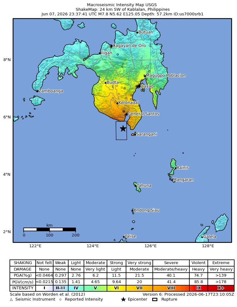
On June 8, 2026, at approximately 0:37 local time, a magnitude 7.8 earthquake, with a depth of 55 km, struck 26 km Southwest of Kablalan, Philippines. The coordinate of epicenter of the earthquake was 5.59N, 125.05E.
The Philippine Sea plate is bordered by the larger Pacific and Eurasia plates and the smaller Sunda plate. The Philippine Sea plate is unusual in that its borders are nearly all zones of plate convergence. The Pacific plate is subducted into the mantle, south of Japan, beneath the Izu-Bonin and Mariana island arcs, which extend more than 3,000 km along the eastern margin of the Philippine Sea plate. This subduction zone is characterized by rapid plate convergence and high-level seismicity extending to depths of over 600 km. In spite of this extensive zone of plate convergence, the plate interface has been associated with few great (M>8.0) ‘megathrust’ earthquakes. This low seismic energy release is thought to result from weak coupling along the plate interface (Scholz and Campos, 1995). These convergent plate margins are also associated with unusual zones of back-arc extension (along with resulting seismic activity) that decouple the volcanic island arcs from the remainder of the Philippine Sea Plate (Karig et al., 1978; Klaus et al., 1992).
South of the Mariana arc, the Pacific plate is subducted beneath the Yap Islands along the Yap trench. The long zone of Pacific plate subduction at the eastern margin of the Philippine Sea Plate is responsible for the generation of the deep Izu-Bonin, Mariana, and Yap trenches as well as parallel chains of islands and volcanoes, typical of circum-pacific island arcs. Similarly, the northwestern margin of the Philippine Sea plate is subducting beneath the Eurasia plate along a convergent zone, extending from southern Honshu to the northeastern coast of Taiwan, manifested by the Ryukyu Islands and the Nansei-Shoto (Ryukyu) trench. The Ryukyu Subduction Zone is associated with a similar zone of back-arc extension, the Okinawa Trough. At Taiwan, the plate boundary is characterized by a zone of arc-continent collision, whereby the northern end of the Luzon island arc is colliding with the buoyant crust of the Eurasia continental margin offshore China.
Along its western margin, the Philippine Sea plate is associated with a zone of oblique convergence with the Sunda Plate. This highly active convergent plate boundary extends along both sides the Philippine Islands, from Luzon in the north to the Celebes Islands in the south. The tectonic setting of the Philippines is unusual in several respects: it is characterized by opposite-facing subduction systems on its east and west sides; the archipelago is cut by a major transform fault, the Philippine Fault; and the arc complex itself is marked by active volcanism, faulting, and high seismic activity. Subduction of the Philippine Sea Plate occurs at the eastern margin of the archipelago along the Philippine Trench and its northern extension, the East Luzon Trough. The East Luzon Trough is thought to be an unusual example of a subduction zone in the process of formation, as the Philippine Trench system gradually extends northward (Hamburger et al., 1983). On the west side of Luzon, the Sunda Plate subducts eastward along a series of trenches, including the Manila Trench in the north, the smaller less well-developed Negros Trench in the central Philippines, and the Sulu and Cotabato trenches in the south (Cardwell et al., 1980). At its northern and southern terminations, subduction at the Manila Trench is interrupted by arc-continent collision, between the northern Philippine arc and the Eurasian continental margin at Taiwan and between the Sulu-Borneo Block and Luzon at the island of Mindoro. The Philippine fault, which extends over 1,200 km within the Philippine arc, is seismically active. The fault has been associated with major historical earthquakes, including the destructive M7.6 Luzon earthquake of 1990 (Yoshida and Abe, 1992). A number of other active intra-arc fault systems are associated with high seismic activity, including the Cotabato Fault and the Verde Passage-Sibuyan Sea Fault (Galgana et al., 2007).
Relative plate motion vectors near the Philippines (about 80 mm/yr) is oblique to the plate boundary along the two plate margins of central Luzon, where it is partitioned into orthogonal plate convergence along the trenches and nearly pure translational motion along the Philippine Fault (Barrier et al., 1991). Profiles B and C reveal evidence of opposing inclined seismic zones at intermediate depths (roughly 70-300 km) and complex tectonics at the surface along the Philippine Fault.
Several relevant tectonic elements, plate boundaries and active volcanoes, provide a context for the seismicity presented on the main map. The plate boundaries are most accurate along the axis of the trenches and more diffuse or speculative in the South China Sea and Lesser Sunda Islands. The active volcanic arcs (Siebert and Simkin, 2002) follow the Izu, Volcano, Mariana, and Ryukyu island chains and the main Philippine islands parallel to the Manila, Negros, Cotabato, and Philippine trenches.
Seismic activity along the boundaries of the Philippine Sea Plate (Allen et al., 2009) has produced 7 great (M>8.0) earthquakes and 250 large (M>7) events. Among the most destructive events were the 1923 Kanto, the 1948 Fukui and the 1995 Kobe (Japan) earthquakes (99,000, 5,100, and 6,400 casualties, respectively), the 1935 and the 1999 Chi-Chi (Taiwan) earthquakes (3,300 and 2,500 casualties, respectively), and the 1976 M7.6 Moro Gulf and 1990 M7.6 Luzon (Philippines) earthquakes (7,100 and 2,400 casualties, respectively). There have also been a number of tsunami-generating events in the region, including the Moro Gulf earthquake, whose tsunami resulted in more than 5000 deaths.
Building Damage
Following the magnitude 7.8 earthquake off the southern Philippines on June 8, 2026, building damage was reported near the epicenter and prominently in and around General Santos City, where footage showed several buildings partially collapsing and reports described multiple collapses and extensive damage [1][6]. General Santos was described as the worst affected or hard-hit area, with several mostly low-rise buildings collapsing or sustaining heavy damage, while separate reports noted collapsed multi-story buildings and numerous smaller structures across the region that collapsed or sustained severe damage [5][7][8]. Specific damage in General Santos included damaged shops and buildings with broken signs and glass, structures reduced to piles of concrete and rubble, damaged convenience stores, cracked building walls, and a collapsed Jollibee fast food restaurant or popular hamburger joint [2][3][7][10][12]. Responders conducted rescue operations and assessed collapsed buildings in General Santos City, and damage with smoke was also reported near General Santos International Airport [2][9]. Additional reported building impacts included damage in a residential area at Peta Timur village in Sangihe Islands Regency, Indonesia's North Sulawesi province, and reported structure and building collapses in Davao City [2][11]. Authorities warned residents to check homes and other structures before entering because aftershocks could cause damaged buildings and houses to collapse [4][10].
Infrastructure Impact
Airport infrastructure was affected in General Santos, where reports described massive damage at General Santos International Airport following the earthquake [11]. The Civil Aviation Authority of the Philippines announced that operations at General Santos International Airport were suspended due to the earthquake [15], and General Santos Airport suspended operations for safety assessments [14]. The international airport in General Santos was temporarily shut, with 17 domestic flights canceled, according to the Civil Aviation Authority of the Philippines [13].
Resilience and Recovery
The June 8, 2026 magnitude-7.8 offshore earthquake in southern Mindanao produced severe community impacts, with later reporting placing casualties at 53 deaths and 17 missing; other reports listed 37 deaths and approximately 487–500 injuries, indicating discrepancies in evolving casualty accounting [22][26][27]. Earlier reports identified General Santos as a major affected urban area, including reports of victims in the port city, which has a population exceeding 700,000 [29][30]. The event also disrupted power and communication networks near the epicentre, compounding immediate response challenges in affected areas [23]. Authorities issued tsunami warnings across the Philippines and neighboring countries, prompting coastal evacuations in the southern Philippines, Indonesia, Malaysia, and Japan [21][26][28]. Philippine President Ferdinand Marcos Jr. suspended school classes in affected areas of Mindanao and called on coastal residents to evacuate immediately [20]. Philippine authorities and PHIVOLCS advised residents in vulnerable coastal areas, including Sarangani, Sulu, and Davao Occidental, to move to higher ground or farther inland [24][15]. In Indonesia, officials directed orderly evacuations in high-risk areas including Manado City, Gorontalo Province, and the Sangihe archipelago [24]. Tsunami warnings were cancelled after more than six hours in the southern Philippines, northern Indonesia, and Sabah, Malaysia [18]. Immediate response actions included mobilization of Philippine military and disaster response teams to verify death and injury reports across Mindanao [16]. Manila also stepped up search and rescue operations as the reported death toll rose and dozens of injuries were recorded by disaster officials [17]. The Philippine Red Cross was documented inspecting earthquake damage in General Santos on June 8, 2026 [25]. Separately, the Vietnamese Embassy in the Philippines reported that no Vietnamese citizens had been identified as earthquake victims at the time of its update [19].
PAGER Estimates
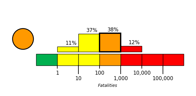
USGS PAGER tool estimated the fatalities to be in the orange alert level, which is most likely between 100 and 1,000 with a probability of 38%.
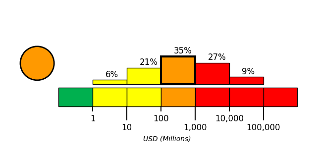
USGS PAGER tool estimated the economic loss to be in the orange alert level, which is most likely between 100 and 1,000 million dollars with a probability of 35%.
References
- [1] bnonews.com - https://bnonews.com/index.php/2026/06/major-8-2-earthquake-strikes-philippines-tsunami-threat-issued
- [2] floridatoday.com - https://www.floridatoday.com/picture-gallery/news/world/2026/06/08/philippines-earthquake-tsunami-warning-photos/90457373007
- [3] oneindia.com - https://www.oneindia.com/international/7-8-magnitude-earthquake-shakes-philippines-tsunami-warning-issued-014-8111523.html
- [4] newsbreak.com - https://www.newsbreak.com/greenmatters-510756/4701093780298-the-philippines-has-been-rocked-by-a-massive-earthquake
- [5] ajc.com - https://www.ajc.com/news/2026/06/a-78-magnitude-earthquake-rocks-the-southern-philippines-causing-some-damage-and-a-tsunami-warning
- [6] indianexpress.com - https://indianexpress.com/article/world/philippines-earthquake-video-buildings-rubble-death-toll-updates-10729098
- [7] businesstimes.com.sg - https://www.businesstimes.com.sg/international/8-2-magnitude-earthquake-strikes-mindanao-philippines-tsunami-warning-issued
- [8] aol.com - https://www.aol.com/articles/devastating-magnitude-7-8-earthquake-023531000.html
- [9] m.economictimes.com - https://m.economictimes.com/us/news/philippines-earthquake-in-videos-watch-buildings-collapse-airport-damaged-as-massive-7-8-quake-strikes-mindanao/articleshow/131576781.cms
- [10] houstonpublicmedia.org - https://www.houstonpublicmedia.org/npr/2026/06/08/g-s1-126830/a-7-8-magnitude-earthquake-rocks-the-southern-philippines
- [11] lokmattimes.com - https://www.lokmattimes.com/international/philippines-earthquake-buildings-collapse-after-magnitude-82-quake-strikes-off-mindanao-coast-tsunami-alert-issued-a517
- [12] tribuneindia.com - https://www.tribuneindia.com/news/world/philippines-earthquake-terrifying-visuals-show-buildings-collapsing-students-sway-amid-tremors
- [13] local.newsbreak.com - https://local.newsbreak.com/new-york-post-509648/4697571076073-a-7-8-magnitude-quake-in-the-philippines-kills-at-least-16-fells-buildings-and-sets-off-a-tsunami
- [14] aol.com - https://www.aol.com/articles/7-8-magnitude-earthquake-strikes-031510000.html
- [15] ecns.cn - https://www.ecns.cn/m/cns-wire/2026-06-09/detail-ihffinvk9813366.shtml
- [16] straitstimes.com - https://www.straitstimes.com/asia/se-asia/earthquake-of-magnitude-7-3-strikes-mindanao-philippines-gfz-says
- [17] srnnews.com - https://srnnews.com/earthquake-of-magnitude-7-3-strikes-mindanao-philippines-gfz-says
- [18] thestar.com.my - https://www.thestar.com.my/news/world/2026/06/08/earthquake-of-magnitude-73-strikes-mindanao-philippines-gfz-says
- [19] vietnam.vn - https://www.vietnam.vn/en/tinh-hinh-nguoi-viet-trong-dong-dat-tai-philippines
- [20] hindustantimes.com - https://www.hindustantimes.com/world-news/philippines-earthquake-videos-building-mindanao-collapses-panic-water-waves-tremors-watch-terrifying-visuals-101780890713410.html
- [21] en.haberler.com - https://en.haberler.com/a-7-8-magnitude-earthquake-struck-the-philippines-2265224
- [22] ground.news - https://ground.news/article/many-feared-trapped-under-earthquake-rubble-in-philippines
- [23] indiatoday.in - https://www.indiatoday.in/science/story/philippines-earthquake-what-triggered-the-7-8-mindanao-quake-and-why-the-region-is-vulnerable-2923386-2026-06-08
- [24] vietnam.vn - https://www.vietnam.vn/en/dong-dat-manh-7-8-do-o-philippines-it-nhat-19-nguoi-chet-da-xuat-hien-song-than-cao-1-4m
- [25] thestar.com - https://www.thestar.com/news/world/asia/a-list-of-deadly-earthquakes-in-the-philippines/article_65bd25c5-9d0c-5422-b81a-6248f82bb510.html
- [26] dnaindia.com - https://www.dnaindia.com/world/report-philippines-earthquake-death-toll-stands-at-37-thousands-homeless-no-power-3212822
- [27] vietnam.vn - https://www.vietnam.vn/en/dong-dat-tai-philippines-thiet-hai-ve-nguoi-va-cua-tiep-tuc-tang
- [28] lasvegassun.com - https://lasvegassun.com/news/2026/jun/07/a-78-magnitude-earthquake-rocks-the-southern-phili
- [29] channelnewsasia.com - https://www.channelnewsasia.com/asia/philippines-earthquake-mindanao-magnitude-8-2-gfz-6167966
- [30] newkerala.com - https://www.newkerala.com/news/a/saddened-loss-lives-destruction-caused-earthquake-philippines-pm-119.htm